General News
11 December, 2023
Cyclone Jasper weakens but will still have impacts
THE latest Bureau of Meteorology (BOM) update has the system remaining at a category 1 system with sustained winds near the centre of 85km/h with gusts up to 120km/h.
UPDATE 8.30am
Gale force winds of 120km/h expected this afternoon as Cyclone Jasper draws closer
WINDS of up to 120km/h along the Far North coast are expected this afternoon as Tropical Cyclone Jasper edges close to the region.
The Bureau of Meteorology (BOM) says the cyclone is expected to cross the coast tomorrow.
The warning zone is from Cape Flattery to Townsville (not including Townsville), but including Cairns, Innisfail and Palm Island, extending inland to include Chillagoe.
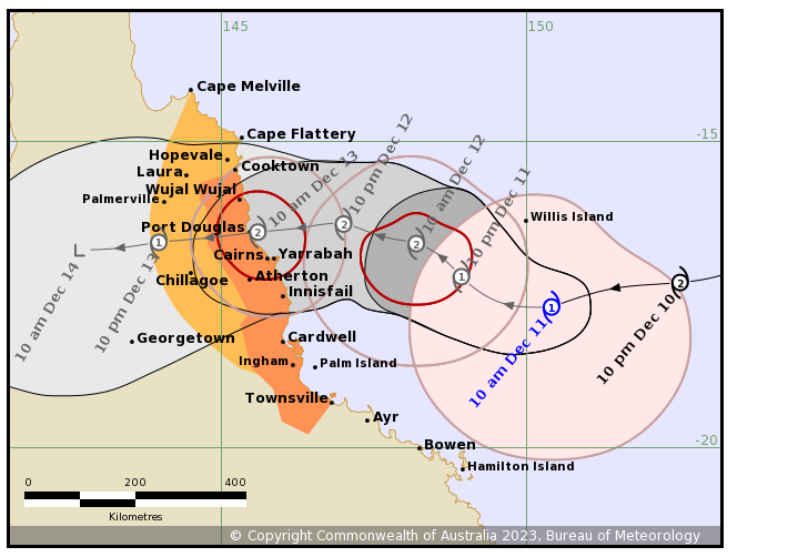
As at 7am today, the category 1 cyclone has sustained winds near the centre of 85km/h with wind gusts to 120km/h. It is estimated to be 265 kilometres east northeast of Cairns and 350 kilometres north northeast of Townsville.
“Tropical Cyclone Jasper, currently a category 1 system, is expected to re-intensify today as it moves west northwest towards the coast,” said BOM in a bulletin.
“It is forecast to cross the coast as a category 2 system on Wednesday, most likely between Cooktown and Innisfail. Jasper will weaken as it moves inland during Thursday towards the Gulf of Carpentaria.
“If the system is slower and crosses overnight Wednesday or Thursday morning, a slim chance remains of a severe category 3 crossing.
“Destructive winds of up to 140 km/h are expected to develop between Wujal Wujal and Innisfail, including Cairns from early Wednesday morning.
“Gales with damaging winds of up to 120 km/h are expected to develop along the Queensland coast and adjacent ranges between Cape Flattery and Townsville, including Cairns, from this afternoon.
“These damaging winds are expected to extend inland to Palmerville and Chillagoe after the cyclone has crossed the coast on Wednesday.
“Gales with damaging winds may extend as far north as Cape Melville on Wednesday, depending on the movement of Jasper.
“Heavy rainfall which may lead to flash flooding is forecast to develop from early Wednesday morning between Cape Flattery and Ingham. Six-hourly totals between 100 to 150 mm are likely, with isolated falls of 250 mm possible along the coast and adjacent ranges. 24-hourly rainfall totals between 150 to 250 mm are likely, with isolated falls up to 350 mm possible.
“A flood watch is current for the North Tropical Coast, parts of the Cape York Peninsula and Gulf Country.
“As the cyclone approaches the coast, a storm tide is expected between Cooktown and Townsville on the high tides today and Wednesday. Large waves may produce minor flooding along the foreshore.
“People living in areas likely to be affected by this flooding should take measures to protect their property as much as possible and be prepared to help their neighbours.”
UPDATE 11.47AM
THE latest Bureau of Meteorology (BOM) update has the system remaining at a category 1 system with sustained winds near the centre of 85km/h with gusts up to 120km/h.
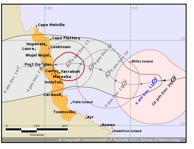
According to BOM, category 1 Jasper was moving west at 19km/h and as of 10.46am on Monday (December 11) was 505Km east of Cairns.
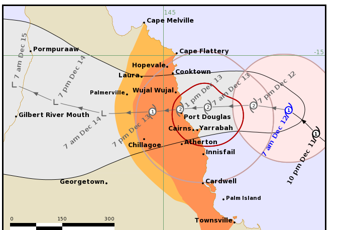
The latest tracking map has the centre striking Port Douglas at 10am on Wednesday.
“Tropical Cyclone Jasper remains a category 1 system. It may weaken slightly further today as it tracks in a general westwards direction,” says BOM.
“Jasper is forecast to re-intensify during Tuesday as it approaches the coast. The system is now forecast to cross as a category 2 system on Wednesday, most likely between Cape Flattery and Cardwell.
“Jasper will weaken as it moves inland during Thursday towards the Gulf of Carpentaria.
“If the system is slower and crosses overnight Wednesday or Thursday, a slim chance remains of a severe category 3 crossing.
THE Bureau of Meteorology has downgraded Tropical Cyclone Jasper to a category 1 and says it most likely cross the Far North Queensland coast on Wednesday as a category 2 as it reintensifies the closer it gets to land.
According to the Bureau of Meteorology (BOM), category 1 Jasper was moving west at 20km/h and as of 4am on Monday (December 11) was 600km east of Cairns.
“Tropical Cyclone Jasper has weakened into a category 1 system and may weaken slightly further during Monday as it tracks in a general westwards direction. Jasper is forecast to re-intensify during Tuesday as it approaches the coast,” the bureau said.
“The system is now forecast to cross as a category 2 system as it makes landfall during Wednesday, most likely between Cape Flattery and Cardwell,” it said.
“Jasper will weaken as it moves inland during Thursday towards the Gulf of Carpentaria. If the system is slower and crosses overnight Wednesday or Thursday, a slim chance remains of a severe category 3 crossing.
“Damaging winds of 90km/h are expected to develop along the Queensland coast between Cooktown and Cardwell, including Cairns from Tuesday.
“Damaging winds of 90km/h may extend as far south as Townsville or as far north as Cape Melville depending on the movement of Jasper.
“Heavy rainfall is expected to develop along the coast from late Tuesday, extending inland during Wednesday. A flood watch is current for the north tropical coast, parts of the Cape York Peninsula and Gulf Country.
“As the cyclone approaches the coast, a storm tide is expected between Cooktown and Townsville. Large waves may produce minor flooding along the foreshore. People living in areas likely to be affected by this flooding should take measures to protect their property as much as possible and be prepared to help their neighbours.”
In the meantime the Cairns Local Disaster Management Group (LDMG) says Tropical Cyclone Jasper could cause a storm surge to properties in the red, orange and yellow storm tide zones across the Cairns region.
Visit the https://www.disaster.cairns.qld.gov.au/ or use https://www.cairns.qld.gov.au/community-environment/natural-disasters/storm-surge to see if you are in a storm tide zone.
Storm surge is when coastal waters rise above highest tide levels because of a cyclone. The tsunami-like waves can go a long way inland. Storm surge is a threat to life and property. People in these places should prepare now for possible storm surge.
According to the LDMG, big waves and sea water will travel a long way inland and through coastal creeks and rivers. This can flood and damage buildings, wash away roads and cars, and damage bridges.
Roads could be blocked by fallen trees, powerlines or flood water from the cyclone.
There will be lots of wind and rain from the cyclone. There will be flooding in low-lying areas.
Power, water, phone and sewerage services could stop working.
What you should do
Decide now where you will go if the storm surge starts. This should be with family and friends in safer, ‘higher’ locations, outside threatened zones.
Consider booking accommodation outside the storm tide zones.
If you have children make sure they are with you or an adult you trust.
If you have no other options, stay informed for the location of public storm tide cyclone shelters to be announced in coming days, if required.
Prepare your home now
Put chemicals and poisons up high to stop them polluting the water.
Lift important things onto beds, benches, tables, high shelves or upstairs to protect them.
Block toilets, sinks and drains with sandbags to stop sewerage backflow if you can.
Empty and turn off fridges and freezers.
Be ready to turn off the power, solar, water and gas before you leave home. This will help remove electrical dangers when you come back.
Move cars to high ground away from trees.
Pack an emergency kit now
Battery-powered radio to listen to warnings
Torch and spare batteries
Tinned and packet food and bottled water to last five days enough clothes for five days
Important medicine
Important papers (like ID, insurance papers and passports)
First-aid kit
Mobile phone, charger and charged power bank
Toilet paper, face masks and hand sanitiser
If you have very young children, enough nappies for up to five days, wipes, bottles, formula or baby food. Plan to not have a fridge or microwave
If you have a pet, enough pet food for five days, a lead and/or crate.
Check your family, friends and neighbours know what to do. Help them if you can.
Public Storm Tide Cyclone Shelters are designed to save lives. Be aware:
People should only evacuate when instructed to.
If you don’t live in the RED, ORANGE AND YELLOW zones you will be refused entry.
Photo identification will be required.
You may be locked in for more than 24 hours while the cyclone passes
Water will be provided; bring your own food
Smoking, consumption of alcohol and non-prescriptive drugs is prohibited
Pets are not allowed.
You will be seated throughout the emergency; there are no beds
There is no wi-fi or entertainment.
Know your evacuation route:
If you are advised to evacuate, do so immediately. Don’t wait.
Storm surge evacuation routes can be viewed at Council’s website, or by using the map at the Cairns Disaster Dashboard, and provide guidance on the most direct route out of a storm surge area. Leave yourself plenty of time; there will be a lot of other people evacuating at the same time and roads may be congested.
If you find it hard to move quickly or have special or medical needs
Use your Person-Centred Emergency Plan (P-CEP) now if you have one.
If anyone in your house uses powered medical equipment, like a dialysis machine or ventilator, decide now where you will go in case you lose power.
Call your support person or service to organise transport.
Leaving early is safer than waiting.
If you are a tourist or visitor, camper or caravanner
Campers and caravanners should start packing up now.
If you do not need to be in the area, leaving now is the safest option.
Travel out of the warning area. Check road conditions and plan your route before you leave.
If you have a boat or jet-ski
Take your boat, jet-ski, canoe or kayak out of the water and store securely on land if possible.
If your boat is kept on the water, check your moorings and relocate it to a safer mooring if possible.
If your boat is in a marina, batten down and check-in with the marina manager.
Check your area’s Extreme Weather Contingency Plan on the Maritime Safety Queensland website.
More information
Go to the Cairns Disaster Dashboard for all warnings and updates: https://disaster.cairns.qld.gov.au/
Listen to ABC Far North at 801AM, 95.5FM or 106.7FM.
For weather information, visit the Bureau of Meteorology Queensland website.
For traffic and road closure information, visit the QLD Traffic website or call 13 19 40.
For power outage information, visit the Ergon Energy website.
Public transport information go to Translink
Find out how to get ready for a flood at https://www.cairns.qld.gov.au/community-environment/natural-disasters/flooding
