Community
13 December, 2023
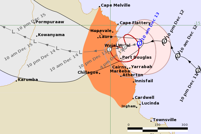
Tropical Cyclone Jasper Update: 10am
TROPICAL Cyclone Jasper is moving in a general west-southwest direction and is beginning to impact the Far North Queensland coast this morning with heavy rain and gusts of strong winds.
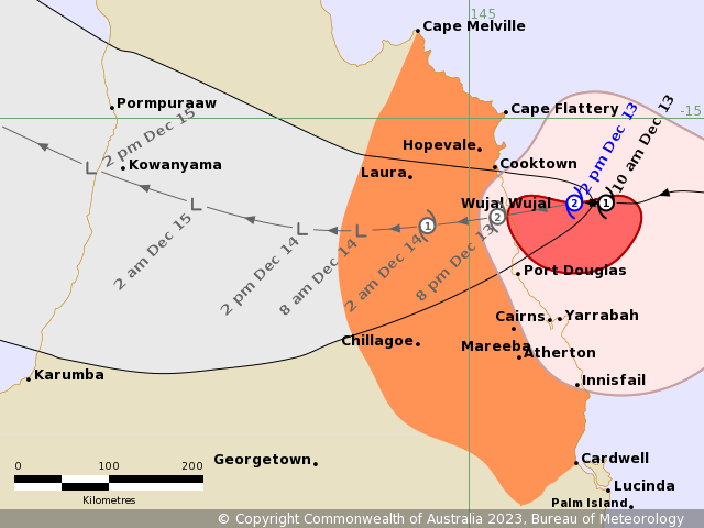
Update: 2pm
Take shelter now as Cyclone Jasper intensifies to a category 2
AN Emergency Alert (Emergency Warning) has been issued for Cairns by the Cairns Disaster Management Group.
Residents are advised to take shelter now in the strongest part of the building they are in as Tropical Cyclone Jasper approaches the coast.
It comes as The Bureau of Meteorology (BOM) says the category 2 cyclone is producing damaging wind gusts on the Far North Queensland coast. Destructive wind gusts may develop during the afternoon.
The warning zone covers Cape Melville to Cardwell, including Cairns and Innisfail and extending inland to include the Atherton Tablelands, Chillagoe and Palmerville.
As at 2pm the cyclone was category 2, with sustained winds near the centre of 95km/h with wind gusts to 130km/h.
It is estimated to be 125 kilometres north of Cairns and 90 kilometres east-southeast of Cooktown and moving at 7km/h.
“Tropical Cyclone Jasper has intensified to a category 2 system and is currently producing damaging wind gusts on the coast.
“Jasper will cross the coast later today and is expected to bring destructive wind gusts during the afternoon. It is expected to weaken overnight as it moves inland, the BOM said in its latest bulletin.
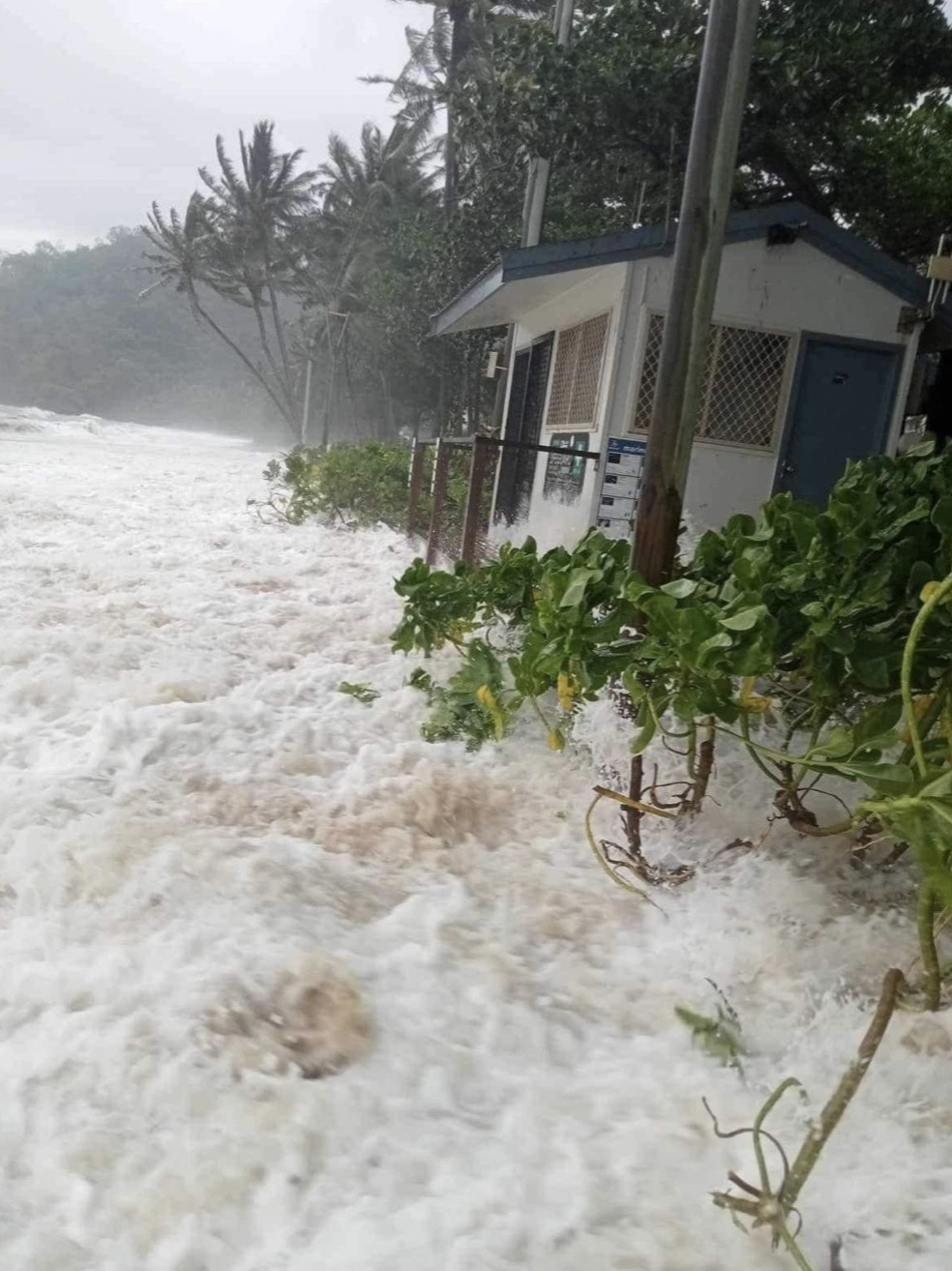
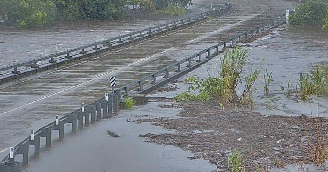
“Locally intense rainfall which may lead to dangerous and life-threatening flash flooding is forecast to develop from this afternoon or evening along the coast and adjacent ranges between Cooktown and Port Douglas as well as areas near the centre of Tropical Cyclone Jasper. Isolated six-hourly rainfall totals between 250 to 300 mm are likely with 24-hourly totals between 400 to 500 mm possible,” it said.
“Heavy rainfall which may lead to flash flooding is also forecast to develop between Cape Flattery and Ingham. Six-hourly rainfall totals between 100 to 150 mm are likely, with isolated falls up to 250 mm along the coast and adjacent ranges. 24-hourly rainfall totals between 150 to 250 mm are likely, with isolated falls up to 350 mm possible.
Please refer to severe weather warning for heavy, locally intense rainfall and damaging winds for people in parts of Peninsula, Gulf Country and Northern Goldfields and Upper Flinders Forecast Districts.
“Destructive wind gusts of up to 140 km/h may develop near and south of the track between Wujal Wujal and Yarrabah including Cairns, from this afternoon.
“Gales with damaging wind gusts of up to 120 km/h are occurring along the coast south of Wujal Wujal, including Cairns.
“Damaging wind gusts are expected to extend further along the coast and adjacent ranges between Cooktown and Innisfail this afternoon. Damaging wind gusts to 90 km/h are possible further south to Cardwell and north to Cape Melville, and then extend inland to the Atherton Tablelands and as far as Palmerville and Chillagoe tonight, after the cyclone has crossed the coast.
“Along the track of the cyclone, damaging wind gusts may begin six hours before the centre crosses a location. The winds are expected to increase to destructive wind gusts near the core of the cyclone, before temporarily easing to lighter winds within the eye as the cyclone passes over.
“A flood watch is current for the north tropical coast, parts of the Cape York Peninsula and Gulf country.
“A storm tide is expected along the north Queensland coast on the high tide later today and during Thursday morning with total waters generally expected to approach or marginally exceed the highest astronomical tide level. Large waves may produce minor flooding along the foreshore.
“People between Wujal Wujal and Innisfail, including Cairns should remain inside until the cyclone has passed and listen to the next advice.
“People in the path of the cyclone should stay calm and remain in a secure shelter while the destructive winds continue.
“Do not venture outside if you find yourself in the eye of the cyclone.
“Heed the advice and follow the instructions of police, emergency services personnel and local authorities.
“Boats and outside property should be secured.
“People between Cape Melville and Cardwell and inland to Chillagoe and Palmerville should take precautions and listen to the next advice.
For cyclone preparedness and safety advice, visit Queensland's Disaster Management Services website (www.disaster.qld.gov.au)
- For emergency assistance call the Queensland State Emergency Service (SES) on 132 500 (for assistance with storm damage, rising flood water, fallen trees on buildings or roof damage).
- If you choose to take shelter away from your home, stay COVID-19 safe and pack a mask and hand sanitiser (if you have them).
- For emergency assistance call the Queensland State Emergency Service (SES) on 132 500 (for assistance with storm damage, rising flood water, fallen trees on buildings or roof damage).
This warning is also available through TV and Radio Broadcasts; the Bureau's website at www.bom.gov.au or call 1300 659 210. The Bureau and the State Emergency Service would appreciate this warning being broadcast regularly.
For more information, listen to local radio or visit https://disaster.cairns.qld.gov.au/. For cyclone assistance or damage, contact the SES on 132 500. In a life-threatening emergency, dial Triple Zero (000).

Areas affected
Warning zone: Cape Melville to Cardwell, including Cairns and Innisfail and extending inland to include the Atherton Tablelands, Chillagoe and Palmerville.
Details of Tropical Cyclone Jasper at 9:00 am AEST:
As at 9am the Bureau of Meteorology said the cyclone was category 1, sustained winds near the centre of 85km/h with wind gusts to 110km/h.
It is 130 kilometres north northeast of Cairns and 115 kilometres east southeast of Cooktown, moving at 15km/h.
“Tropical Cyclone Jasper, currently category 1, is forecast to cross the coast late this afternoon or evening between Hopevale and Cairns,” BOM said in a bulletin.
“Tropical Cyclone Jasper may intensify to category 2 before making landfall but should weaken quickly as it moves inland overnight tonight as it moves over Cape York Peninsula.”
Hazards
“Locally intense rainfall which may lead to dangerous and life-threatening flash flooding is forecast to develop from this afternoon along the coast and adjacent ranges between Cape Flattery and Port Douglas as well as areas near the centre of Tropical Cyclone Jasper.
“Isolated six-hourly rainfall totals between 250 to 300 mm are likely with 24-hourly totals between 400 to 500 mm possible.
“Heavy rainfall which may lead to flash flooding is also forecast to develop between Cape Flattery and Ingham.
“Six-hourly rainfall totals between 100 to 150 mm are likely, with isolated falls up to 250 mm along the coast and adjacent ranges. 24-hourly rainfall totals between 150 to 250 mm are likely, with isolated falls up to 350 mm possible.
“Destructive wind gusts of up to 140 km/h may develop near and south of the track between Wujal Wujal and Innisfail, including Cairns from this afternoon.
“Gales with damaging wind gusts of up to 120 km/h are beginning to develop along the coast and adjacent ranges between Cooktown and Innisfail, including Cairns this morning.
“Damaging wind gusts to 90 km/h are possible further south to Cardwell and north to Cape Melville and then extend inland to the Atherton Tablelands and as far as Palmerville and Chillagoe tonight, after the cyclone has crossed the coast.
“A flood watch is current for the north tropical coast, parts of the Cape York Peninsula and Gulf country.
“As the cyclone approaches the coast, a storm tide is expected between Cooktown and Lucinda on the high tides on Wednesday.
“Large waves may produce minor flooding along the foreshore. People living in areas likely to be affected by this flooding should take measures to protect their property as much as possible and be prepared to help their neighbours.”
Ergon Energy said at 10am according to their Ergon’s Outage Finder, power outages had started as a result of severe weather in Cairns, Innisfail and on the Atherton Tablelands.
"At this stage most of the impact appears to be from vegetation contacting the electricity network," said a spokeswoman..
"As winds pick up, tree branches and other flying debris have the potential to bring down powerlines. Any fallen powerlines should be treated as live and potentially deadly. Stay well away from them and report them to emergency services on 000 or call Ergon on 13 16 70," she said.
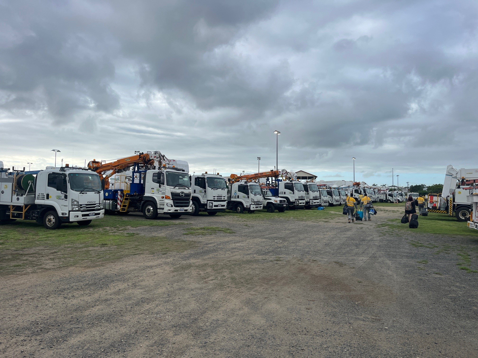
"We have more than 500 field crews across Queensland available to support the restoration effort if required.
"We cannot send crews out in cyclonic conditions, but the trucks are ready to roll when it is safe.
"We also have crews mustering in Townsville and Rockhampton, ready to support their mates in Far North Queensland."
Picture shows crews and trucks mustering in Rockhampton
